-
 fly fishing Sandy Hook
I thought this article was pretty interesting. Capt Jim Freda has a good rep.
http://www.flyfisherman.com/northeast/jfsandyhook/
Sandy Hook Fall Blitzes
Captain Jim Freda

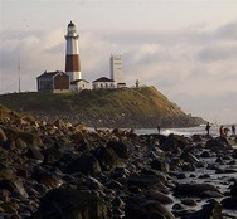
Sandy Hook (above) is a seven-mile barrier spit surrounded by water on three sides. It offers public beach access to world-class striped bass fishing within sight of the New York City skyline.
Intro | Hotspots | Bait | Albies | Bunker | Late Season
The 127 miles of New Jersey coastline has a lot to offer fly fishers who fish the surf and backbay river systems throughout the year. It is late in the fall, however, that our bait migrations take place tight to the beach and put striped bass, bluefish, weakfish, and false albacore right at our feet.
One piece of prime real estate during this fall migration is Sandy Hook. The Hook is a seven-mile barrier spit surrounded by water on three sides. Sandy Hook marks the northern tip of the New Jersey coastline and is within view of the New York City skyline. It is one of more than 360 parks that comprise the Gateway National Recreation Area maintained by the National Park Service. It is also a site on the New Jersey Coastal Heritage Trail. [Click here for a map of the Sandy Hook area. The Editor.]
One of the reasons why Sandy Hook is so productive are the four major river systems that feed her waters. The Hudson, Raritan, Neversink, and Shrewsbury rivers all flow into the New York Bight area, past Sandy Hook and out to the ocean.
The great action both in the surf and along the backbay shorelines begins as early as the middle of September and continues until Christmas if the weather and wind cooperate. The best fishing days in the fall are preceded by a consistent weather pattern and have a light northwest wind. Westerly winds push bait against the beach and is best for shore anglers. A northeast wind puts the wind at the back of shore anglers, roughs up the surf, and disorients the bait. Bass and blues immediately key in on this activity and blitz situations often result, although they are frequently offshore and not within reach of shore anglers.

Striped bass (right) and bluefish are the most common gamefish at Sandy Hook but false albacore also hunt these waters in early fall when anchovy and silversides migrate along the beach.
Approaching hurricanes in the early part of the season can quickly shut the action down, as large swells and crashing waves push the bait off the beach and create turbid water conditions. Normally the water here is clean and clear.
Bait and gamefish remain in the Sandy Hook area until surface temperatures drop below 50 degrees F. This usually doesn't happen until the third week in December but can be accelerated by stiff northwest winds and cold fronts dropping down out of Canada just after Thanksgiving.
If icy cold weather does come through, the bait quickly vacates the surf zone and the season for shore anglers comes to an early close. In the absence of bait near the beach, striped bass, bluefish, and false albacore quickly move off into 20 to 70 feet of water to find the bait.
Hook Hotspots
There are several productive locations on Sandy Hook worth investigating during the fall run. As you drive onto Sandy Hook from Route 36 or Ocean Avenue you see the historic Twin Lights of the Highlands overlooking the Shrewsbury River and the Highlands Bridge. Cross over this bridge to access the Hook. A nominal fee is charged at the toll gate from Memorial Day through Labor Day. Fishing is permitted at any unguarded (non-swimming) beach during daylight hours during this time period. In the off-season, all ocean beaches are open to fishing. A permit is required to park at night on the Hook. Get a permit if you plan to fish late or before the sun comes up. Purchase the permits at the Ranger Station inside the toll gate.

North Beach (above) at Sandy Hook has a steep dropoff where striped bass and bluefish often trap schools of bait.
The first Sandy Hook location worth investigating is adjacent to the toll gate. Park in the nearby lot and walk a short distance east to the ocean or west to the Shrewsbury River. On the ocean beach there is deep water a short distance from shore. Because of the quickly sloping topography of the beach, bait holds tight to the shoreline. Striped bass, bluefish, and false albacore sometimes blitz up and down this stretch attacking pods of bait. Often these fish push the bait right up onto the sand making hero casts unnecessary.
On the west side of the toll gate, the Shrewsbury River runs into Sandy Hook Bay. There is an old boat channel that runs parallel to the shore that is within casting range. This channel drops off quickly to about 12 feet so sinking lines are necessary to fish this location whenever there is a strong current. During slack tide, intermediate or floating lines are effective. Caution should be exercised when wading out at this location as one or two steps too many will take you off of your feet.

The Shrewsbury River (above) on the bay side of Sandy Hook has a deep boat channel frequented by bass and bluefish.
The other feature on the Shrewsbury River just north of the toll gate is Plum Island. Gain access by parking in the second lot after you drive onto the Hook. Here you will find several points that stick out into the boat channel. These positions get you closer to the channel and offer an added advantage. Get there early if you plan to fish this spot.

The rubble from an abandoned military bunker (above) north of Horseshoe Cove projects into the bay and is a good spot to fish when the tide is moving.
North of Plum Island is Skeleton Island and the surrounding waters of Spermaceti Cove. This area has an excellent combination of channels, flats, cuts, and drop-offs. It is a good place to seek shelter from the wind when it is blowing hard out of the northeast. Work the cuts around Skeleton Island during the outgoing tide when bait flushes through these narrow passageways. Foot access is adjacent to Parking Areas C, D, and the Visitor Center. Further north you find Horseshoe Cove, which is another location that can have good striped bass or bluefish action in the fall. It is also sheltered from the wind. There is also an old abandoned bunker with extending rubble where you can stand and cast into the bay.

Horseshoe Cove (above) and Spermaceti Cove—both on the bay side of Sandy Hook—are good places to find shelter from the wind. Fish the nearby cuts where stripers wait to ambush their prey on a dropping tide.
Both coves serve as staging areas for mullet, peanut bunker, and spearing before they make their exodus out of the bay into the ocean. It is usually the early part of the fall, late September and early October, when bait is present here. Later in the season, during November and early December, the water is usually too cold. Don't spend too much time in these locations if no bait is present. Move to the ocean where the water is warmer in the fall.
The historic Fort Hancock section of Sandy Hook is home to a U.S. Coast Guard base. At the northern end of this section is the true tip of Sandy Hook and an area known to boaters as "The Rip." The Rip has received much attention over the years and is known as one of the best locations in the state to land big bass.
Swift currents move through this location on the changing of the tides. Baits are helplessly swept out from the bay in the strong current and take refuge close to the shore to get out of the heavy flow. This gives shore fly fishers an opportunity to target large stripers and blues that pin these baits against the shore.
 Posting Permissions
- You may not post new threads
- You may not post replies
- You may not post attachments
- You may not edit your posts
-
Forum Rules


 Reply With Quote