-
 2 mile beach to be used for plover refuge?
So they shut down the loran capability. Now they are looking for uses for it. Aren't their better uses than plover habitat? Isn't Sandy Hook enough? How about making it more accessible for fishermen.
http://www.pressofatlanticcity.com/n...cc4c03286.html
As Coast Guard shuts down Loran, site of Cape facility eyed for piping plover nesting
By RICHARD DEGENER Staff Writer | Posted: Wednesday, January 20, 2010 | 6 comments
- <LI done14="118" done13="118" done12="118" done11="118" done10="118" done7="118" done4="118">
 <LI done14="119" done13="119" done12="119" done11="119" done10="119" done7="119" done4="119"> <LI done14="120" done13="120" done12="120" done11="120" done10="120" done7="120" done4="120">
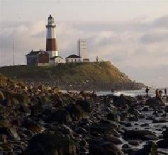
LOWER TOWNSHIP — The U.S. Coast Guard’s Loran radio navigation center here has helped mariners and aviators navigate safely for more than six decades. It may soon help breed piping plovers.
That’s the hope of the U.S. Fish and Wildlife Service, which wants to acquire 520 coastal acres here at the southern tip of Two-Mile Beach, where the U.S. Coast Guard has operated its Loran network since 1947.
The Wildlife Service took over 550 acres of the base in 1999 and used it to create the Two-Mile Beach Unit of the Cape May National Wildlife Refuge.
With the Coast Guard getting ready to scuttle its Loran system under a budgetary move announced by President Barack Obama’s administration last year, the base will close for good sometime this year. The service is considering doubling the size of the refuge, as the law allows another federal agency to have first crack at unused land.
“We’ve made our interest known. It’s the only closed beach and only protection for nesting shorebirds for 40 miles from Cape May to Atlantic City. It’s extremely important to them,” said Howard Schlegel, manager of the Cape May National Wildlife Refuge.
Schlegel said nests of the endangered piping plover already have been spotted on the Coast Guard property and it is a key spot for many other shorebirds.
What comes next
The General Services Administration will decide what to do with the site. In 1998, it received more than 50 requests when the Coast Guard vacated half the property, including one from the township to create a fire station.
Cmdr. Gary M. Thomas, who will serve as the last commanding officer of the Loran Support Unit, said the bill terminating the program allows the Coast Guard to at least recover the costs of decommissioning it. After that, other federal agencies are offered the property at no charge. If there is no interest, then state and local governments get a chance, Thomas said.
If the Wildlife Service gets the property, Schlegel said, the beach would be closed from April 1 to Sept. 30 for the piping plovers, but would have public access for the rest of the site. The Two-Mile Beach Unit has a parking lot, visitor contact center, maintenance building and walkways that are accessible to the disabled, and there are plans to build a wildlife viewing platform, Schlegel said.
The service probably would want to demolish the buildings that are part of the Loran Support Unit. The 625-foot-high Loran antenna, one of the tallest objects on the southern New Jersey coast, and one decorated by the Coast Guard personnel at Christmas, also may go, because it could pose a threat to migrating birds, Schlegel said.
Along with another 40 acres the service acquired in 2004 near Middle Thorofare Bridge, it would give the service well more than 1,000 acres that could revert to a coastal maritime forest.
“This would be really adding to what we’ve been trying to do at Two-Mile Beach and certainly a positive for the shorebirds,” Schlegel said.
Two Mile Beach timeline
1690: Map shows it as island between Cold Spring Inlet and Turtle Inlet.
1720s: Early county resident Aaron Leaming Sr. grazes cattle on the island known locally as Two Mile Beach.
1756: Map now shows inlet to north renamed Turtle Gut Inlet.
1776: Battle of Turtle Gut Inlet on June 29 when the American brigantine Nancy is deliberately run aground to evade capture by a British force. Americans booby-trap ship with gunpowder, killing as many as 40 British boarders.
1777: Salt works established to aid Revolutionary War effort.
1828: One of first maps to list the island as Two Mile Beach.
1854: Life Saving Station authorized but it doesn’t appear in records until 1873.
1902: Cape May Real Estate Company gets title to site.
1907: Congress authorizes construction of Cold Spring Inlet.
1908: Spoils from dredging inlet and Cape May Harbor used to fill lowlands at Two Mile Beach.
1919: Cape May County begins filling Turtle Gut Inlet to develop Wildwood Gables, today’s Wildwood Crest. Pennsylvania Railroad later fills for rail line.
1923: Lifesaving Station No. 38, manned by a crew of nine, is under water during an October storm.
1925: Life Saving Station discontinued.
1937: Witmer Stone’s book ‘Bird Studies at Old Cape May’ talks about beauty of Two Mile Beach.
1938: Ocean Drive constructed, linking Two Mile Beach to Five Mile Beach (the Wildwoods).
1947: U.S. Coast Guard takes over site and opens its Long Range Navigation, or Loran, system there.
1999: U.S. Fish and Wildlife Service turns half of base into a wildlife refuge.
2009: President Barack Obama announces plans to end Loran network.
2010: Loran to end and rest of base to become available.
 Posting Permissions
- You may not post new threads
- You may not post replies
- You may not post attachments
- You may not edit your posts
-
Forum Rules


 Reply With Quote