-

some more pics
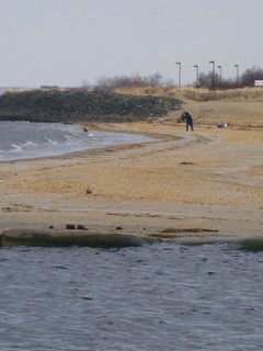
Showing the proposed areas that will be fenced in. That's a pretty large area!
-
Another shot of the area that will receive the most pressure when the fences go up. A lot of people utilize these areas for recreation... fishermen, families, joggers, people exercising their dogs, and handicapped people.
The day I was there, I saw a younger girl drive her handicapped Dad to the parking lot where the proposed closing is, just to look at the beach. He looked in pretty bad shape,, and could barely fit in the car. After a few minutes of viewing the bay, they left. I imagine there are a lot of people whose enjoyment would be diminshed if the fences are put up.
Furthermore, it seems to impact fishermen and the poorer people unfairly, as anyone who has money to use that water and fish there will be able to do so from a boat or kayak. Where's the equity in that? 
Resident's Comments:
I met a local fisherman who spends a lot of time out there. He had a lot to say about the dumping, and some of the other companies who dumped in the Raritan Bay for years, without anyone even registering a protest.
He said:
"There were a lot of guys dumping here in the 70's and 80's, National Lead were supposed to be involved, along with Spiral Metal and Terracotta Barrel Co, and a few others. They also dredged a lot of the sand from the Arthur Kill and dumped it on this side of the bay."
(I can't confirm any of this, I wasn't around then. I'm only reporting what he said.)
-
Economic impact
The local tackle shops have had down trending years (for the past 3) because of the recession and other issues. This closure could very well be the "straw that breaks the camel's back"
2 local shops, Fred's of S Amboy/Morgan and Skippy's of Laurence Harbor, are worried about their future.
I had a chance to talk with Kash of Fred's Tackle shop:
Kash is pretty friendly, but the talk got serious when we discussed the closing of the bayfront areas by the EPA and how it will affect his business.
He said: "I don't know what I'm going to do. Business has been down every year for the last 3 years to the point where this year my business is 55% of what it was 3 years ago. If another year is bad like the past ones, I will be very worried. This beach closure will have a bad affect on me.. I know the economy is bad, and everyone is scared to spend money. But other tackle shops have closed - Ray's Sporting goods, T&A tackle, some in NY, and I wonder if I won't be the next one to close!"
Despite all that, he could have made bitter statements about the EPA, but didn't. 
He said: "I know the EPA is just doing their job. In fact, an EPA guy was here the other day to buy bait to go fishing! So I try to understand, but I want them to understand we are all hurting down here. This closure could finish us off for good!"
-
Old Bridge Public meeting with EPA and concerned citizens 4-1-09
The meeting was pretty well attended by town residents. Honestly, I thought a few more fishermen might have decided to come down, but the ones that came made some good points and raised some important questions.
Blanche from town hall coordinated all the questions and answers, she did a great job. 
Overview:
The EPA officials presented the findings, showed us some maps of where the contamination was found, and talked about the areas that would be closed. They were helpful in answering almost everyone's questions, and offered to come back, sit in on meetings in the future, and keep a dialogue going. There were websites and hotlines posted so people could get the latest info and findings. When that stuff becomes available, I'll post it here. I'll also post the links.
I'm trying to do this by being fair and balanced, and present the good with the bad. I don't think it's smart for anyone who writes about this, whether in the newspapers, magazines, or internet forums, to talk about how the sky is falling. Yeah, the contamination there is serious. If a diligent effort was made to dig soil samples, I would guess there might be some levels of chemical contamination at many points of the Raritan Bay. You could also probably go to any bay near a major metropolitan area along the East Coast and find some level of chemical contamination, somewhere. Chemicals have been dumped down storm sewers and in rivers for years without thought of the consequences. Unfortunately, they wind up in the bays and estuaries.
Realistically, the levels of lead contamination from Sayreville to Cliffwood are horrendously above the recommended maximums. This closure could very well be one of the largest Superfund sites in recent years. There's no way to sugercoat this. From the charts they presented to us, IMO this thing will get a lot bigger than reported by the time they're done with all the testing. I feel this is just the tip of the iceberg.
However, since I started reporting on stuff like this, I realized we who report have an ethical responsibility.
Reporting the truth is admirable. Reporting the truth so it panics people is not being fair and balanced, in my opinion. So I hope this story I'm laying down here will come out as fair and balanced.
I try my best, but anyone who has any factual corrections to what I report here, please let me know and I will edit. I don't want to scare people here. If some of my words mobilize people to take action to get this place cleaned up sooner rather than later, I will feel I've made a contribution. Thanks for reading, people. 
-
www.epa.gov/region02/superfund
History and background:
Raritan Bay Slag
Sayreville, NJ
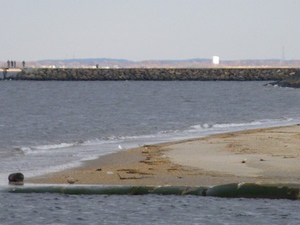
The Raritan Bay Slag Site is located in the Laurence Harbor section of Old Bridge and in Sayreville, Middlesex County, New Jersey. The Laurence Harbor seawall, which makes up part of the Site, was reported to have had metal slag from blast furnace bottoms deposited along the beachfront in the late 1960s and early 1970s.
Approximately 2,500 feet of the seawall have been contaminated. Elevated levels of lead, antimony, arsenic and copper have been identified by the New Jersey Department of Environmental Protection (NJDEP) along the seawall near the area where the processing by-products were deposited. While site investigations were being conducted another area of concern was identified on the Sayreville waterfront. This area consists of the western jetty at the Cheesequake Creek inlet and waterfront area. At the request of the NJDEP, EPA evaluated the Raritan Bay Slag site for a removal action under Superfund.
Samples collected previously by the NJDEP from the nearby beach and park were evaluated by the New Jersey Department of Health and Senior Services. Old Bridge Township placed a temporary fence around the area of concern and posted warning signs in the park along the edge of the seawall. Letters were sent to the residents of Laurence Harbor in 2007 to notify them of NJDEP’s findings.
The removal assessment, which also includes the gathering of historical information and available data, is ongoing. The assessment will include the collection of soil, sediment, water, biological and waste samples along the seawall, jetty and the beaches near the areas of concern.
-
Meeting 4-1-09
Preliminary findings:
They found that the activity based sampling shows lead levels much higher than static (stationary) testing. That's one of their reasons for shutting it down. They're worried about children and pregnant woman being exposed to these higher levels, and the health implications.
They went into detail about the 3 main areas, which caused me and some other people to have a concern. This could turn out to be a lot bigger than they originally estimated. How big, and how costly, is anybody's guess.
1. Morgan creek jetty up to the seawall at the right of the first beach. (areas 2 & 4 in the graphs) Lead levels of up to 190,000 ppm were found here, as opposed to a recommended ceiling of 400 ppm.
2. The first jetty behind the Dunkin Donuts in Lawrence Harbor to the gazebo. (areas 3&5 in the graphs)
3. Margaret's Creek area. (area 6 in the graphs) Lead levels of up to 100-120,000 ppm in this area that borders Cliffwood Beach, with 400 ppm being the norm.
Basically, large and small slag kettles, battery casings, and round lead castings are found scattered throughout this whole area. The Morgan Creek Jetty is littered with hundreds of these things. I have climbed that jetty dozens of times and never knew what they were until now.
-
Questions and answers:
Following are a series of questions and answers as the residents and other interested parties were allowed to ask whatever we wanted, and the EPA answered.
It was a positive thing to see them not discriminate, other than giving the town's residents first chance at the podium.
We didn't have this courtesy at Brookhaven LI where they would only take written questions and limited the question period, despite the nearly 70 fishermen who showed up to protest the beach closure there.
Marine Life- how will it be affected?
The EPA advised to limit consumption of flatfish based on already existing advisories. One a month for flounder, and one a week for fluke. Both of these fish eat creatures that live in the mud there. The same goes for crabs, which live in the mud, they said no one should be eating the crabs there. Studies are still being done on the other marine life such as striped bass, which are migratory and eat from the mud everywhere they go, including contaminated areas in the Hudson, Raritan, Delaware and other rivers.
The EPA said that as soon as further studies were completed they would be released.
Will you be targeting fishermen for prosecution if they tresspass?
There wasn't too much of a clear answer on this. The concern of the EPA is for peoples' safety. They're concerned for fishermen as well. As the fences are put up, fishermen who approach from the water will still be able to fish. I don't know how much of an active role local police will play in enforcement if fishermen do approach this way. If they're below the high tide line, it could become a Public Trust Access issue.
However, in this case, I don't know if public safety precludes Public Trust rights.
What I heard at that meeting is they don't want to encourage fishermen to fish that water, even if they are able to. We'll have to see how this plays out.
Is the lead airborne?
There were no concrete answers on this, but the general consensus was that it was not an issue unless partially burned in some of the brush fires they have back there. It was recommended that any firefighters fighting those fires wear respirators.
Is it safe to have a "Saltwater Day" there?
There's a local businessman who holds a Saltwater Day every year, and he was assured it would be safe. It seems the highest concentration of lead is on the sand at the beaches, and lead that has leached out from the slag and lead kettles used to build the jetty walls.
It doesn't seem to be an issue further back where the EPA said no appreciable levels of contamination were found. So they say it's safe to bring your kids there and use the parks as recreation, as long as they don't go near the sand or water.
As they said this, in my mind I was thinking: What parent would be comfortable bringing their children here knowing of the risk? There are other options for recreation for parents to bring their kids to, and it's my feeling they'll avoid this area.
How can you deal with water contamination if the lead is leaching into the water?
The EPA admitted it was very difficult to prevent this, and alluded to future studies that would be made to assess how far out the lead contamination is found to be.
Kash from Fred's Bait and Tackle: "Business people are at risk now. I don't want to criticize the EPA because you people are only doing your job. However, you need to decide on a reasonable plan to deal with this so people will still come down to our area."
The EPA said it recognized the hardships people would face, and would try to communicate clearly its findings and attend as many local meetings as possible to answer residents' questions.
Bill Naused, a local resident since 1969: " The bulkheads were built with slag. Liberty Trucking, one of the contractors for the backfill, used slag and whatever he could find. That's the way they did things back then. When the County took over, why didn't anybody spot this? Everybody who lives here knew about it. How come nothing was done?
The EPA was very interested in talking to Bill further. I had a chance to meet Bill, and he's quite knowledgable about the area and everything that was going on for the last 40 years. He would be a valuable resource to the EPA should they decide to "fast track" this and get things going so it doesn't take 10 years.
I imagine there are many people in that town who have similar knowledge as Bill. If anyone who reads this knows a few, please tell them that now is the time for them to speak up. 
What is the proposed timetable for this cleanup?
This is one area where I might not be able to remain unbiased. They said this was just the preliminary stages. There would be more testing, assessments, and meetings. There is not enough $$ in the budget to fix this particular problem, hence putting it on the superfund list. The best estimates they could come up with are that remediation could take 5 to 10 years.
What is the proposed cost of this cleanup?
The EPA kind of hedged its bets on this one, and I don't blame them. Figures were tossed around, some saying it could cost in the 10s of millions to remediate and finally make safe for all to use again. Some of the other audience members, who were connected with engineering firms, disputed that figure, saying it could cost up to $100 million.
I think it's fair to say how much the actual costs are at the end of the road for this project is subject to whoever is doing the estimating.
 Posting Permissions
- You may not post new threads
- You may not post replies
- You may not post attachments
- You may not edit your posts
-
Forum Rules


 Administrator

 Reply With Quote